
World
World
24 Jan, 2026
Philippines Prepares for Heavy Rainfall and Potential Flooding as Tropical Disturbance Develops
Samantha Rodriguez
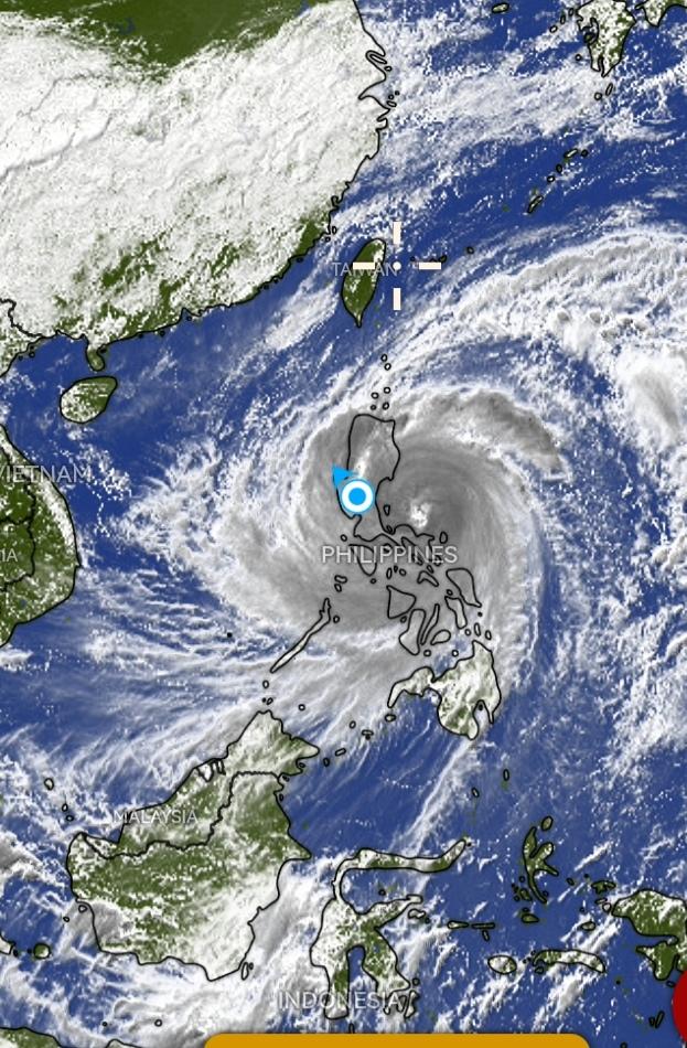
The Philippines is bracing for significant rainfall as a low-pressure area (LPA) inside the Philippine Area of Responsibility shows a high probability of developing into a tropical depression within 24 hours. The Philippine Atmospheric, Geophysical, and Astronomical Services Administration (PAGASA) reported that the LPA was last located approximately 445 kilometers east of Hinatuan, Surigao del Sur as of 8 p.m. on Sunday, November 23.
Should the LPA intensify into a tropical depression, it will be locally named Verbena. PAGASA Weather Specialist Grace Castañeda indicated that the potential tropical cyclone is forecast to move west-northwest, impacting northeastern Mindanao, the Visayas, and northern Palawan.
Regions expected to experience the strongest rains initially include Caraga and Eastern Visayas, along with portions of the Bicol region and the provinces of Bohol and Misamis Oriental.
PAGASA provided a detailed rainfall outlook as follows:
-
Sunday evening, November 23 to Monday evening, November 24: Heavy to intense rainfall (100-200 mm) is anticipated in Eastern Samar, Surigao del Norte, and Dinagat Islands. Moderate to heavy rainfall (50-100 mm) is forecast for Albay, Sorsogon, Northern Samar, Samar, Leyte, Biliran, Southern Leyte, Bohol, Agusan del Norte, Agusan del Sur, Surigao del Sur, and Misamis Oriental.
-
Monday evening, November 24 to Tuesday evening, November 25: Heavy to intense rain is expected in Albay, Sorsogon, Masbate, Romblon, Oriental Mindoro, Southern Leyte, Leyte, Biliran, Cebu, Bohol, Negros Occidental, Capiz, Iloilo, and Dinagat Islands. Moderate to heavy rain covers a broader range, including Occidental Mindoro, Marinduque, Palawan, Catanduanes, Camarines Norte, Camarines Sur, Northern Samar, Samar, Eastern Samar, Negros Oriental, Siquijor, Antique, Aklan, Guimaras, Surigao del Norte, Surigao del Sur, Agusan del Norte, Agusan del Sur, Misamis Oriental, Camiguin, and Bukidnon.
-
Tuesday evening, November 25 to Wednesday evening, November 26: Heavy to intense rain will affect Aklan, Antique, Palawan, Occidental Mindoro, and Oriental Mindoro. Moderate to heavy rain is expected in Quirino, Nueva Vizcaya, Cavite, Batangas, Laguna, Camarines Sur, Camarines Norte, Catanduanes, Albay, Marinduque, Romblon, Capiz, Iloilo, Guimaras, and Negros Occidental.
Aside from the LPA, an additional source of rainfall is the shear line influenced by the northeast monsoon (amihan) and easterly winds from the Pacific Ocean. This shear line will continue to bring rain to eastern Luzon provinces and, within 48 hours, heavier rains will extend to more areas including Metro Manila.
Rainfall from the shear line between Sunday evening, November 23 and Monday evening, November 24 includes moderate to heavy rain (50-100 mm) over Cagayan, Isabela, Aurora, and Quezon. From Monday evening, November 24 to Tuesday evening, November 25, similar rainfall amounts are expected in Cagayan, Isabela, Apayao, Kalinga, Aurora, and Quezon. Heavy to intense rainfall (100-200 mm) from Tuesday evening, November 25 to Wednesday evening, November 26 will impact Isabela, Aurora, and Quezon, with moderate to heavy rain forecast in Metro Manila and nearby provinces including Rizal, Nueva Ecija, Bulacan, Cagayan, Apayao, Kalinga, Mountain Province, and Ifugao.
PAGASA has warned that these weather disturbances increase the risk of floods and landslides in vulnerable areas. Authorities urge residents to remain vigilant and closely monitor official weather updates to take necessary precautions.
Recommended For You

MORE Power Announces November Electricity Rate Increase in Iloilo City
Jan 24, 2026
Carmela Diaz

Lumbaca Unayan Declares Liberation from Terrorist Influence, Launches New Peace Task Force
Jan 24, 2026
Emmanuel Santos

DA and DoLE Launch Emergency Rehabilitation for Bicol’s Abaca Farmers Affected by Typhoons
Jan 24, 2026
Carmela Diaz
Aboitiz Foods Tops AmCham CSI Awards with Transformative Community Programs
Jan 24, 2026
Ricardo Fernandez